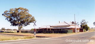
Hotels in Milbrulong, New South Wales
Former Boundary Inn Hotel
Former Boundary Inn Hotel Hotel was closed in November 1999.
Information on Milbrulong, NSW

Milbrulong is a locality in the central east part of the Riverina region of New South Wales, Australia, located 515 kilometres southwest of Sydney and 59 kilometres southwest of Wagga Wagga in the Lockhart Shire.
This small rural village sits between The Rock and Lockhart and has significant Wiradjuri heritage - Milbrulong being the Wiradjuri word for rosella. The Lutheran Church and Cemetery is located just outside of the village, with the Milbrulong State Forest nearby.
Local tourism links
Travel options
Access to Milbrulong is primarily by road, being positioned between the larger towns of The Rock and Lockhart. The village serves as a stop along regional driving routes through the Riverina.
A highlight in the region is the National picolight fly-in, which is hosted annually in Milbrulong in September each year, indicating aviation access for specialized events. The town is easily accessible as a day trip from the regional center of Wagga Wagga.
- Lockhart (12km)
- Pleasant Hills (22km)
- Yerong Creek (24km)
- The Rock (25km)
- Boree Creek (28km)
- Henty (32km)
- Collingullie (33km)
- Uranquinty (38km)
- Mangoplah (39km)
- Rand (43km)

